Santa Ana Estancia: Difference between revisions
imported>Robert A. Estremo mNo edit summary |
imported>Robert A. Estremo m (city link / GPS coord) |
||
| Line 6: | Line 6: | ||
|- | |- | ||
|<small>'''Location:''' | |<small>'''Location:''' | ||
|Costa Mesa, California | |[[Costa Mesa, California]] | ||
|- | |||
|<small>'''Coordinates:''' | |||
|<small>33° 40′ 23″ N, 117° 56′ 13″ W | |||
|- | |- | ||
|<small>'''Name as Founded:''' | |<small>'''Name as Founded:''' | ||
| Line 30: | Line 33: | ||
|<small>'''Current Use:''' | |<small>'''Current Use:''' | ||
|Museum | |Museum | ||
|- | |- | ||
|<small>'''California Historical Landmark:''' | |<small>'''California Historical Landmark:''' | ||
Revision as of 01:39, 25 January 2013
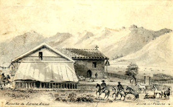
 Rancho Santiago de Santa Ana, 1870s.[1] Rancho Santiago de Santa Ana, 1870s.[1]
| |
| HISTORY | |
|---|---|
| Location: | Costa Mesa, California |
| Coordinates: | 33° 40′ 23″ N, 117° 56′ 13″ W |
| Name as Founded: | Estancia de La Misión de San Juan Capistrano de Sajavit |
| English Translation: | Station of The Mission of Saint John Capistrano of Sajavit |
| Military District: | First [2] |
| Native Tribe(s): Spanish Name(s): |
Tongva Gabrieliño [3] |
| Primordial Place Name(s): | Lukup [3] |
| DISPOSITION | |
| Caretaker: | City of Costa Mesa |
| Current Use: | Museum |
| California Historical Landmark: | #227 |
| Web Site: | http://www.costamesahistory.org/adobe.htm |
The Santa Ana Estancia (known at times throughout the years as the Costa Mesa Estancia, the Diego Sepúlveda Adobe, the Gabe Allen Adobe, or the Polloreno Adobe) is an adobe structure built between 1817 and 1823 to house the mayordomo and herdsmen who tended the cattle and horses from nearby Mission San Juan Capistrano.
History
During his 1769 expedition into Alta California Father Junípero Serra named the area that today comprises the vast majority of Orange County Vallejo de Santa Ana (the Valley of Saint Anne, or Santa Ana Valley). Strategically situated on the banks of the Santa Ana River some six leguas (Spanish Leagues) north of the parent mission, the way-station also served as a lookout post when the French privateer Hipólito Bouchard attacked San Juan Capistrano on December 14, 1818.[4] By 1820 the building and its surrounding lands became an official estancia (station, generically referred to as an estate or ranch), after which padres from the mission would visit regularly to bring "spiritual food" to the faithful.[5] The Adobe and its surrounding property (a portion of the Rancho Santiago de Santa Ana) were deeded to Don Diego Sepúlveda (a former alcalde of the Pueblo of Los Angeles) around 1868.[4] In 1872, lumber was used to repair the damaged adobe and to build a frame addition. The Adobe, which has since been restored to its original style using original construction methods, is the second oldest building still standing in Orange County, California, after Mission San Juan's "Serra's Chapel." Today the facility is maintained by the Costa Mesa Historical Society as a museum.