File:Nonattainment Areas Map.png

Original file (611 × 657 pixels, file size: 104 KB, MIME type: image/png)
Summary
| Title / Description
|
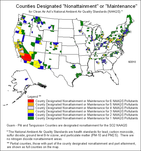
Map of counties in the United States with air quality that does not meet the National Ambient Air Quality Standards as of June 2009 |
|---|---|
| Author(s)
|
The United States Environmental Protection Agency |
| Source
|
http://www.epa.gov/air/oaqps/greenbk/mapnmpoll.html |
| Date created
|
June 1, 2009 |
| Country of first publication
|
United States |
| Notes
|
You can edit this page and add notes here which may be useful to people who wish to re-use this media. |
| Other versions
|
If there are other versions of this media on CZ, please list them here. |
| Using this image on CZ
|
Copy the code below to add this image to a Citizendium article, changing the size, alignment, and caption as necessary.
|
Please send email to manager A T citizendium.org .
Licensing/Copyright status
This media, Nonattainment Areas Map.png, is in the public domain
This is a work of the United States Government, and as such is not afforded copyright protection under US law.
For further information see Title 17, Chapter 1, Section 105 of the US Code.
You may freely copy, distribute, display and perform this work, as well as make derivative and commercial works.
This image's copyright information has been verified by Drew R. Smith on 08:28, 29 August 2009 (UTC).
File history
Click on a date/time to view the file as it appeared at that time.
| Date/Time | Thumbnail | Dimensions | User | Comment | |
|---|---|---|---|---|---|
| current | 19:54, 11 March 2022 | | 611 × 657 (104 KB) | Maintenance script (talk | contribs) | == Summary == Importing file |
You cannot overwrite this file.
File usage
The following 3 pages use this file: