Darfur: Difference between revisions
imported>Howard C. Berkowitz No edit summary |
imported>Howard C. Berkowitz No edit summary |
||
| Line 1: | Line 1: | ||
{{subpages}} | {{subpages}} | ||
{{seealso|Darfur Conflict}} | {{seealso|Darfur Conflict}} | ||
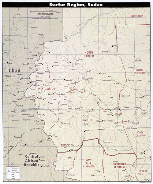
'''Darfur''', in the west of [[Sudan]], is a remote area, whose name means "Land of the Fur", the [[Fur (ethnic group)|Fur]] being one of its pastoralist resident groups. It has three main towns: | [[Image:Sudan darfur 2007.jpg|500px|Thumb|right|Darfur region]] | ||
*El Fasher, the site of the main airport in the region | '''Darfur''', in the west of [[Sudan]], is a remote area, whose name means "Land of the Fur", the [[Fur (ethnic group)|Fur]] being one of its pastoralist resident groups. It has three provinces and main towns: | ||
*Nyala, on the western border with [[Chad]] and on the insecure railroad, in the central part and considered the regional capital | *El Fasher in North Darfur Province, the site of the main airport in the region | ||
*El Geneina | *Nyala in West Darfur Province, on the western border with [[Chad]] and on the insecure railroad, in the central part and considered the regional capital | ||
*El Geneina in South Darfur Province | |||
[[Chad]] forms most of the western border, with a small stretch with the [[Central African Republic]]. The Bahr Al Ghazal provinces to the south are part of semiautonomous South Sudan, while the north and east borders are with the Khartoum government. | |||
==Economy== | |||
Historically, the economy has been agricultural, at a subsistence level. | |||
Oil concessions have been defined in the Kordofan provinces, and it is likely that oil exists somewhere in Darfur. There are working oilfields in south [[Chad]]. | |||
There is virtually no transportation infrastructure. One of the problems of flying in humanitarian supplies is that while the El Fasher airport does have reasonable navigational aids, aviation fuel either has to be flown in, or brought over extremely insecure roads. The Nyala-El Fasher road is gravel, which can be described only as an improvement over dirt. | |||
Revision as of 13:32, 27 November 2009
- See also: Darfur Conflict
Darfur, in the west of Sudan, is a remote area, whose name means "Land of the Fur", the Fur being one of its pastoralist resident groups. It has three provinces and main towns:
- El Fasher in North Darfur Province, the site of the main airport in the region
- Nyala in West Darfur Province, on the western border with Chad and on the insecure railroad, in the central part and considered the regional capital
- El Geneina in South Darfur Province
Chad forms most of the western border, with a small stretch with the Central African Republic. The Bahr Al Ghazal provinces to the south are part of semiautonomous South Sudan, while the north and east borders are with the Khartoum government.
Economy
Historically, the economy has been agricultural, at a subsistence level.
Oil concessions have been defined in the Kordofan provinces, and it is likely that oil exists somewhere in Darfur. There are working oilfields in south Chad.
There is virtually no transportation infrastructure. One of the problems of flying in humanitarian supplies is that while the El Fasher airport does have reasonable navigational aids, aviation fuel either has to be flown in, or brought over extremely insecure roads. The Nyala-El Fasher road is gravel, which can be described only as an improvement over dirt.
