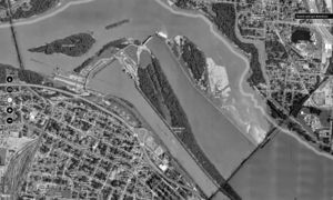
Information for "File:Aerial photograph of the Ohio River, at Louisville, showing the artificial canal to the south, and the (submerge) location of the Falls of the Ohio.jpg"
Jump to navigation
Jump to search
View the protection log for this page.
Basic information
| Display title | File:Aerial photograph of the Ohio River, at Louisville, showing the artificial canal to the south, and the (submerge) location of the Falls of the Ohio.jpg |
| Default sort key | Aerial photograph of the Ohio River, at Louisville, showing the artificial canal to the south, and the (submerge) location of the Falls of the Ohio.jpg |
| Page length (in bytes) | 654 |
| Namespace | File |
| Page ID | 1840 |
| Page content language | en - English |
| Page content model | wikitext |
| Indexing by robots | Allowed |
| Number of redirects to this page | 0 |
| Hash value | 5093fa26f6542a747867f196f56bc21b4a7a2a10 |
| Page image |  |
Page protection
| Edit | Allow all users (infinite) |
| Move | Allow all users (infinite) |
| Upload | Allow all users (infinite) |
Edit history
| Page creator | imported>George Swan |
| Date of page creation | 08:13, 4 March 2022 |
| Latest editor | George Swan (talk | contribs) |
| Date of latest edit | 20:54, 18 April 2022 |
| Total number of edits | 3 |
| Total number of distinct authors | 3 |
| Recent number of edits (within past 90 days) | 0 |
| Recent number of distinct authors | 0 |
Page properties
| Transcluded templates (7) | Templates used on this page: |