User:George Swan/my maps: Difference between revisions
Jump to navigation
Jump to search
imported>George Swan (→9) |
imported>George Swan (reformat) |
||
| (3 intermediate revisions by the same user not shown) | |||
| Line 5: | Line 5: | ||
Image:Polar siberia.png | Image:Polar siberia.png | ||
Image:Orthographic projection over Vladisvostok.png | Image:Orthographic projection over Vladisvostok.png | ||
Image:Orthographic projection over Svalbard.png | Image:Orthographic projection over Svalbard.png | ||
Image:Orthographic projection over Qaanaag.png | Image:Orthographic projection over Qaanaag.png | ||
Image:Orthographic projection over Labrador City.png | Image:Orthographic projection over Labrador City.png | ||
Image:Orthographic projection over Grise Fjord.png | Image:Orthographic projection over Grise Fjord.png | ||
Image:Orthographic projection over Bathurst Inlet, Nunavut.png | Image:Orthographic projection over Bathurst Inlet, Nunavut.png | ||
Image:Orthographic projection centred over sisimiut.png | Image:Orthographic projection centred over sisimiut.png | ||
Image:Orthographic projection centred over Nakhodka.png | Image:Orthographic projection centred over Nakhodka.png | ||
Image:Orthographic projection centred over Magadan.png | Image:Orthographic projection centred over Magadan.png | ||
Image:Orthographic projection centred over Churchill, Manitoba, Canada.png | Image:Orthographic projection centred over Churchill, Manitoba, Canada.png | ||
Image:Orthographic projection centred over Bremen and the Weser watershed.png | Image:Orthographic projection centred over Bremen and the Weser watershed.png | ||
Image:Orthographic projection centred on the Avalon Peninsula.png | Image:Orthographic projection centred on the Avalon Peninsula.png | ||
Image:Orthographic projection centered over Iqaluit.png | Image:Orthographic projection centered over Iqaluit.png | ||
Image:Orthographic projection centered over Iqaluit with latitude and longitude.png | Image:Orthographic projection centered over Iqaluit with latitude and longitude.png | ||
Image:North pole september ice-pack 1978-2002.png | Image:North pole september ice-pack 1978-2002.png | ||
Image:North pole february ice-pack 1978-2002.png | Image:North pole february ice-pack 1978-2002.png | ||
Image:Orthographic projection over Tobago - with Galveston - New Orleans - St Helena.png | Image:Orthographic projection over Tobago - with Galveston - New Orleans - St Helena.png | ||
Image:Orthographic projection over Palmyra Atoll.png | Image:Orthographic projection over Palmyra Atoll.png | ||
Image:Orthographic projection over Kingman Reef.png | Image:Orthographic projection over Kingman Reef.png | ||
Image:Orthographic projection over Jarvis Island.png | Image:Orthographic projection over Jarvis Island.png | ||
Image:Orthographic projection over Diego Garcia.png | Image:Orthographic projection over Diego Garcia.png | ||
Image:GPLed Grand River.png | |||
Image:Thunder Bay Ontario.png | |||
Image:Wawa Ontario.png | |||
Image:Walpole island ontario.png | |||
Image:Tiksi - Siberia - Laptev Sea.png | |||
Image:Polar siberia 4.png | |||
Image:Dudinka and dikson 2.png | |||
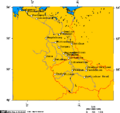
Image:Arctic Ocean Seaports.png|Image:Arctic Ocean Seaports.png | |||
Image:Orthographic projection centred over the Galapagos.png | Image:Orthographic projection centred over the Galapagos.png | ||
Image:Orthographic projection centred over midway.png | Image:Orthographic projection centred over midway.png | ||
Image:Orthographic projection centred over St Peter and St Paul Rocks.png|Image:Orthographic projection centred over St Peter and St Paul Rocks.png | Image:Orthographic projection centred over St Peter and St Paul Rocks.png|Image:Orthographic projection centred over St Peter and St Paul Rocks.png | ||
Image:Orthographic projection centred over Pitcairn Island.png|Image:Orthographic projection centred over Pitcairn Island.png | Image:Orthographic projection centred over Pitcairn Island.png|Image:Orthographic projection centred over Pitcairn Island.png | ||
Image:Orthographic projection centred over Juan Fernandez.png|Image:Orthographic projection centred over Juan Fernandez.png | Image:Orthographic projection centred over Juan Fernandez.png|Image:Orthographic projection centred over Juan Fernandez.png | ||
Image:Orthographic projection centred over Ile Amsterdam.png|Image:Orthographic projection centred over Ile Amsterdam.png | Image:Orthographic projection centred over Ile Amsterdam.png|Image:Orthographic projection centred over Ile Amsterdam.png | ||
| Line 56: | Line 42: | ||
Image:Orthographic projection centred over Easter Island.png|Image:Orthographic projection centred over Easter Island.pn | Image:Orthographic projection centred over Easter Island.png|Image:Orthographic projection centred over Easter Island.pn | ||
Image:Indian Ocean.png|Image:Indian Ocean.png | Image:Indian Ocean.png|Image:Indian Ocean.png | ||
Image:Orthographic projection over the larsen b ice shelf.png | |||
Image:Orthographic projection over the Heard Islands.png | |||
Image:Orthographic projection over Raoul Island.png | |||
Image:Orthographic projection over Gough Island.png | |||
Image:Orthographic projection centred over the Bounty Islands.png | |||
Image:Orthographic projection centred over Wallis and Futuna Islands.png | |||
Image:Orthographic projection centred over South Georgia Island.png | |||
Image:Orthographic projection centred over Ross Island.png | |||
Image:Orthographic projection centred over King George Island.png | |||
Image:Orthographic projection centred over Kerguelen Island.png | |||
Image:Orthographic projection centred on the South Sandwich Islands.png | |||
Image:Orthographic projection centered over Bouvet Island.png | |||
Image:Orthographic projection centered on the Prince Edward Islands.png | |||
Image:Drake Passage - Orthographic projection.png | |||
Image:Avalon peninsula - Newfoundland.png | |||
Image:Cape breton island.png | |||
Image:Churchill river newfoundland and churchill falls.PNG | |||
Image:Marine Atlantic ferry ports.png | |||
Image:Strait of belle isle.png | |||
Image:Alaska north shore.png | |||
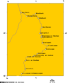
Image:Boothia and melville peninsula 1.PNG | |||
Image:Communities where Inuinnaqtun is spoken.png | |||
Image:Great Bear Lake.png | |||
Image:Great Slave Lake and Lake Athabasca 6.png | |||
Image:Lake Athabasca.png | |||
Image:Lambert Projection of Western Nunavut.png | |||
Image:Lambert Projection showing Bathurst Inlet, Nunavut, and environs.png | |||
Image:Lambert Projection showing the Diavik Diamond Mine, near Barthurst Inlet, Nunavut.png | |||
Image:Lambert Projection showing the Ekati and Diavik Diamond Mine, near Barthurst Inlet, Nunavut.png | |||
Image:Vancouver-island-lambert-azimuthal.png | |||
Image:Vancouver-island-lambert-azimuthal.png | |||
Image:Watershed of the Saskatchewan River.png | |||
Image:Yukon - Kluane Park and Alaska Highway area.png | |||
Image:Brittany - France.png | |||
Image:Elbe watershed.png | |||
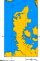
Image:Jutland peninsula.png | |||
Image:Map of cuxhaven hamburg lauenburg lubeck.png | |||
Image:Neckar river watershed.png | |||
Image:Rhine river.PNG | |||
Image:Weser watershed.png | |||
Image:Yenisei basin 7.png | |||
Image:Lake Simcoe Ontario.png | |||
Image:Approximate area of the Niagara Escarpment 2.PNG | |||
</gallery> | </gallery> | ||
Latest revision as of 17:48, 10 April 2008
1


Image:Arctic Ocean Seaports.png
Image:Orthographic projection centred over St Peter and St Paul Rocks.png
Image:Orthographic projection centred over Pitcairn Island.png
Image:Orthographic projection centred over Juan Fernandez.png
Image:Orthographic projection centred over Ile Amsterdam.png
Image:Orthographic projection centred over Fernando de Noronha.png
Image:Orthographic projection centred over Easter Island.pn
Image:Indian Ocean.png