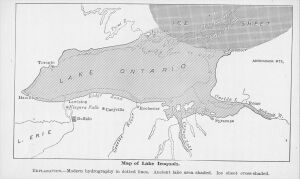
Glacial Lake Iroquois
Glacial Lake Iroquois was a deep lake found in the basin of what is now Lake Ontario that formed as the Laurentide glaciation receded.[1][2] The ice sheet receded from the western end of that basin first, and the basin filled with glacial meltwater. However the area around Kingston, Ontario, where Lake Ontario currently empties into the Saint Lawrence River, was still covered by a lobe of the glacier. This forced Lake Iroquois to be considerably deeper than Lake Ontario.
Lake Iroquois's outlet was on the Lake's southern shore, and large amounts of water flowed down the Mohawk River, to the Hudson River, to the Atlantic Ocean.[3] The valley this outflow carved became the best route for crossing the Appalachian Mountains. Other crossings, like the Cumberland Gap, required traveling over early dirt roads, and trails, over what was a mountain pass. Meanwhile, the Mohawk River and the Mohawk Valley allowed the construction of the Erie Canal. It was cheaper and more pleasant to ship goods and people by water, via the canal, than over primitive roads.
References
- ↑ Ken Sharratt. geology-of-high-park. Retrieved on 2022-08-04. mirror
- ↑ Wayne Reeves, Christina Palassio. HTO, Toronto's Water from Lake Iroquois to Taddle Creek and Beyond, Coach House Books. Retrieved on 2018-09-29.
- ↑ Andrew P. Kitzmann (2009). Erie Canal. Arcadia Publishing. ISBN 9780738562001.
