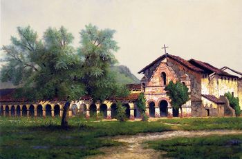
Mission San Antonio de Padua
| This article is part of a series on the Spanish missions in California  Mission San Antonio de Padua, circa 1899.[1] | |
| HISTORY | |
|---|---|
| Location: | Monterey County, California |
| Coordinates: | 36° 0′ 54″ N, 121° 15′ 0″ W |
| Name as Founded: | La Misión de San Antonio de Padua [2] |
| English Translation: | The Mission of Saint Anthony of Padua, Italy |
| Patron Saint: | Saint Anthony of Padua [3] |
| Nickname(s): | "Mission of the Sierras" [4] |
| Founding Date: | July 14, 1771 [5] |
| Founded By: | Father Presidente Junípero Serra [6] |
| Founding Order: | Third [3] |
| Headquarters of the Alta California Mission System: | 1769–1771 [7] |
| Military District: | Third [8] |
| Native Tribe(s): Spanish Name(s): |
Salinan |
| Primordial Place Name(s): | Telhaya [9] |
| SPIRITUAL RESULTS | |
| Baptisms: | 4,419 [10] |
| Marriages: | 1,142 [10] |
| Burials: | 3,617 [10] |
| Year of Neophyte Population Peak: | 1806 [11][12] |
| Neophyte Population: | 640 [11][12] |
| Neophyte Population in 1832: | 1,217 [11][12] |
| Secularized: | 1834 [3] |
| Returned to the Church: | 1862 |
| Caretaker: | Roman Catholic Diocese of Monterey |
| Current Use: | Parish Church |
| Current Land Area: | 85 acres |
| National Historic Landmark: | #NPS-76000504 |
| Date added to the NRHP: | 1976 |
| California Historical Landmark: | #232 |
| Web Site: | http://missionsanantonio.net/ |
Mission San Antonio de Padua is a former religious outpost established by Spanish colonists on the west coast of North America in the present-day State of California (U.S. state). Founded on July 14, 1771 by Roman Catholics of the Franciscan Order, the settlement was the third in the twenty-one mission Alta California chain. Named after a 13th-century Portuguese Catholic priest and friar of the Franciscan Order, the Mission was the site of the first Christian marriage, and was also the first in Upper California to utilize fired-tile clay roofing. Designated as a historic landmark at both the state and national levels, today the Mission serves as a parish church within the Roman Catholic Diocese of Monterey.
History
Mission Period (1769 – 1833)
Father Serra left Fathers Miguel Pieras and Buenaventura Sitjar behind to continue the building efforts, though the construction of the church proper did not actually begin until 1810. By that time, there were 178 Native Americans living at the Mission. By 1805, the number had increased to 1,300, but in 1834, after the secularization laws went into effect, the total number of Indians at the Mission was only 150.
Rancho Period (1834 – 1849)
In 1845, Mexican Governor Pío Pico declared all mission buildings for sale, but no one bid for Mission San Antonio. After nearly 30 years, the Mission was returned to the Catholic Church.
California Statehood (1850 – 1900)
President Abraham Lincoln signed a proclamation on May 31, 1862 that restored ownership of the Mission proper to the Roman Catholic Church.[13] In 1894, roof tiles were salvaged from the property and installed on the Southern Pacific Railroad depot located in Burlingame, California (the first permanent structure constructed in the Mission Revival Style).
20th century and beyond (1901 – present)
The first attempt at rebuilding the Mission came in 1903, when the California Historical Landmarks League rebuilt the chapel walls. Unfortunately, the earthquake of April 18, 1906, seriously damaged the building. In 1928, Franciscan Friars held services at San Antonio de Padua. It took nearly 50 years to completely restore the Mission. No town grew up around the Mission, as many did at other installations. Today, the nearest city is King City, California, nearly 29 miles (47 km) away; Jolon, California, a small town, is located 6 miles (10 km) from the Mission. The Mission is surrounded by the Fort Hunter Liggett Military Reservation, which was acquired by the United States Army from the Hearst family during World War II to train troops. Additional land was acquired from the Army in 1950 to increase the Mission area to over 85 acres (340,000 m²). This fort is still actively training troops today.
Notes and references
- ↑ (PD) Painting: Edwin Deakin
- ↑ Leffingwell, p. 99
- ↑ Jump up to: 3.0 3.1 3.2 Krell, p. 101
- ↑ Weber
- ↑ Yenne. p. 40
- ↑ Ruscin, p. 196
- ↑ Yenne, p. 186
- ↑ Forbes, p. 202
- ↑ Ruscin, p. 195
- ↑ Jump up to: 10.0 10.1 10.2 Krell, p. 315: as of December 31, 1832; information adapted from Engelhardt's Missions and Missionaries of California.
- ↑ Jump up to: 11.0 11.1 11.2 Krell, p. 315: Information adapted from Engelhardt's Missions and Missionaries of California.
- ↑ Jump up to: 12.0 12.1 12.2 Engelhardt 1920, pp. 300-301.
- ↑ Leffingwell, p. 100